Quick Insight: Catherine Nakalembe on Geospatial AI
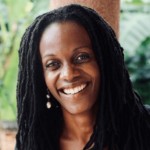
Geographer Catherine Nakalembe, an assistant professor at the University of Maryland, and here she details the intersection of artificial intelligence, mapping technology and small-holder agriculture to improve lives in sub-Saharan Africa. The 2020 Africa Food Prize Laureate for improving the lives of smallholder farmers by using satellite technology to harness data to guide agricultural decision-making, Nakalembe is the Africa Program Director under NASA Harvest, and the Agriculture and Food Security Thematic Lead of the NASA SERVIR Applied Sciences Team.
A transcript of her talk appears below the Quick Insight video.
Hi, I’m Catherine Nakalembe. I’m a professor at the University of Maryland in the Department of Geographical Sciences, and I work on what I call broadly “translational Geo AI.” That is geospatial AI to develop methods to utilize your spatial data, including satellite Earth observations and field data to understand how our world is changing, looking at things like cropland and things like floods, droughts, etcetera might be impacting on communities.
I use the word translation here to mean that while it’s really interesting to develop really cool methods using new tools, etc., it’s even more interesting when you’re able to work with a community that might be affected by, let’s say, a flood or drought and figuring out how our methods and tools can help provide policy frameworks to support those communities, to mitigate or adapt to rapidly changing environment.
One of my most interesting projects right now actually, which I’m conceptualizing, but also I’ve been working on for a little bit, is trying to figure out how to one, understand cacao production in Madagascar, but at the same time, figure out how my understanding of it and how it’s produced and how climate might be affecting its production, how this might be relevant for the farmers who actually grow it and how that connects with no broader climate policy as well as if we’re trying to improve supply chains, etc. How do we ensure that the people who produce these amazing products are actually supported to continue to grow them?
And then the other thing that’s really interesting, my favorite project of all time, I talk about this one all the time, I call it “helmets labeling crops,” which is one of those you could say “Geo for good,” I used to call it “GoPro for good” type of project. One of the biggest challenges we face when you’re looking at smallholder agriculture, so trying to map what crops are growing where and how those crops are doing, is collecting field data. So we need examples of specific things in order to be able to map them with satellite data. So if I’m trying to create a map of, let’s say, soy or maize, I need an example that is a point in the field with a latitude, longitude and the label, which in this case would be maze. When you’re trying to do it over really, really large geographies, it takes a lot of time and effort to collect that data. You have to go from one field to another, etc. We do things like extensive field work, driving miles and miles, walking miles and miles to collect this data.
But one of my favorite projects is, we call it “helmets labeling crops.” And the idea is, use a GoPro as you’re driving a motorcycle or in your car. The GoPro is taking pictures. And then we’ve developed this pipeline that we called “street to sat,” basically coming from the street level images to create that label that I mentioned before.
So imagine face detection software or Google Street View, but in this case, we’re looking for crops, not buildings or faces. And then from that, we’re able to make maps of what crops are growing where.
Once we have that, we can create yield estimates.
Once we understand what yield might be, you would understand whether there’ll be a shortfall in production, but there might be a bump up production, which is a way of figuring out if you need to, one purchase the grain that’s been produced, and or provide support for communities where there might be a shortfall.
So you get to have a lot of fun working with communities and learning how science can be utilized on the ground. At the same time, get to be part of really big teams at NASA or here at the University of Maryland doing some of the most innovative uses of Earth observations, data sets and AI for supporting communities who are farming and producing what makes us all happy: Cacao, chocolate, even bananas.
Thank you.